
Bridges, Viaducts and Causeways
across the Ouse Washes and its Rivers
Page good for smart-phones. On PCs/Laptops it may look too large. To reduce press "Ctrl" & "minus" or click "View" then "Zoom out"
Created Mar 2013, last edited: 21/03/26, 16:03
Created Mar 2013, last edited: 21/03/26, 16:03
Introduction
March 2026
This page is under reconstruction following change to phone friendly display.
We have also re-freshed our slideshow tour of the railway line across the Ouse Washes which has 4 bridges and 2 viaducts, its well worth a visit. Its shows many views you will not have seen before
Scroll on down, or choose a location from the drop-down menu
Denver

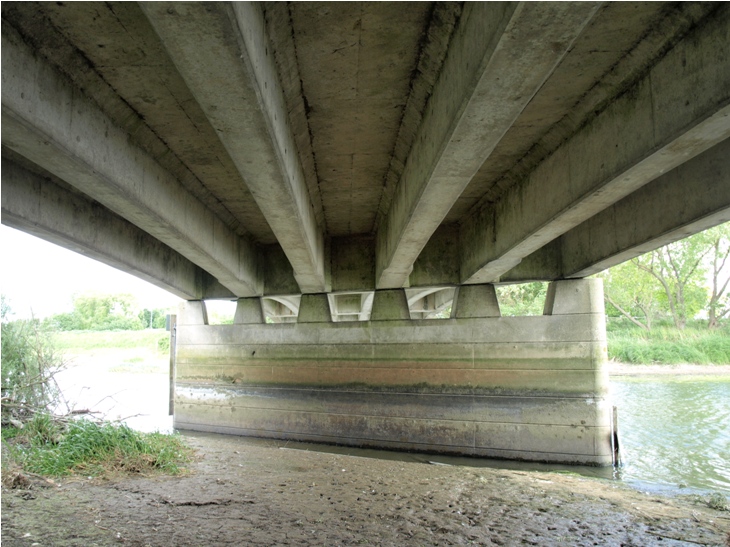
Photo: Peter Cox, Jun 2011
Earith
bridge over New Bedford River
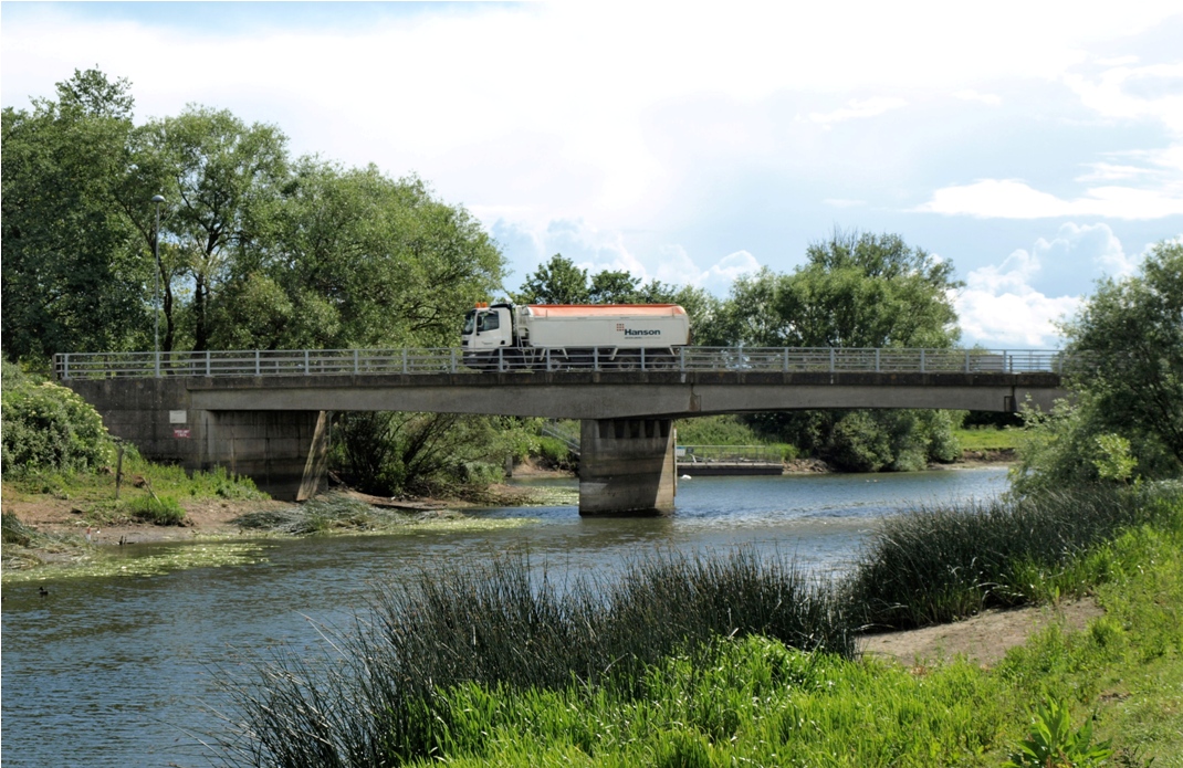
Photo: Peter Cox, Jun 2011

Photo: Peter Cox, Jun 2011
Bridge over sluice at start of Old Bedford River

Photo: Peter Cox, Jun 2011

Google satelite view. North/south on left: 1985 bypass viaduct. East/west: 1930 bridge in village over New Bedford River and route of 1930 viaduct.
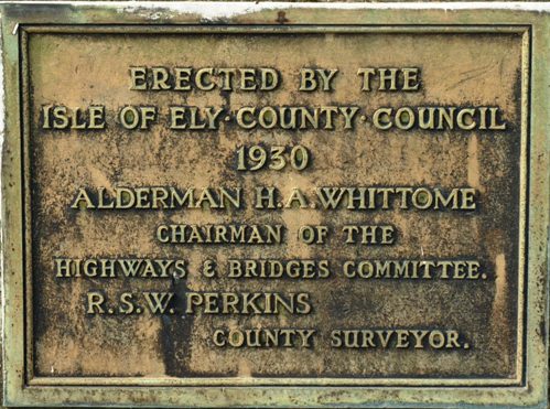
Nice to find a commemerative stone. I've not found one on any other bridge in the washes (so far).
Photo: Peter Cox, Apr 2011
 c1902-1908
Looking south from west bank of NBR. Three Pickerells on left, Red Lion on right.
 c1878-1882..
Looking south from east bank.
 c1898-1902.
Looking south from east bank.
Photos and information above taken from the Mepal Community Archives. Click photos to go to the source page. Many other Mepal photos at
Mepal Community Archives
Mepal
Village

The 1930 concrete bridge above seen in 2011 looking south from the west bank of the New Bedford River. The white bulding is a private house. To the right of the large tree in centre can just be seen the chimney of the Three Pickerels Inn above the bridge parapet, and below that the base of the timber bridge previously here.
Photo: Peter Cox, Apr 2011
The black and white photos show the timber bridge and two pubs, Three Pickerells on the left (still open!) and Red Lion on the right (closed, but when?).
Photo: Mepal Community Photo Archive
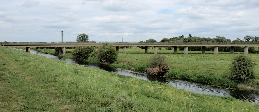
Photo: Peter Cox, May 2011
Looking south from the Old Bedford.
The abutment at the New Bedford end just visible in the far distance.
Photo: Peter Cox, May 2011

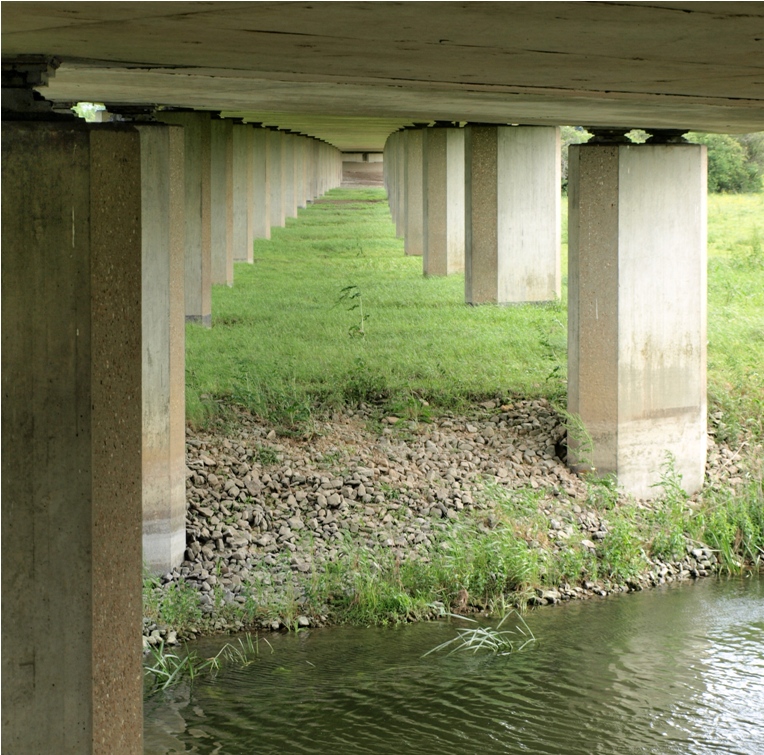
Photo: Peter Cox, May 2011

Looking south from the west side of the viaduct
Photos: Peter Cox, May 2011
A141 By-pass

In 1984/85 a much needed by-pass was built with a continuous viaduct accross both Bedford rivers and the Washes. Seen here in 2011 with Old Bedford River in foreground.
Photo: Peter Cox, May 2011
Engine Bank
Purls Bridge
Railway
Background
For more than 160 years trains have trundled across the washes on a series of bridges and viaducts and an embankment.In 1836 the Eastern Counties Railway (ECR) was incorporated and authorised to build a line from London to Norwich, Yarmouth and Ipswich. In 1844 Parliament gave the Company permission to build a line across the Fens from Ely to Peterborough. Despite the soft peat soil, the line was built in just 10 months opening to goods traffic in December 1846 and to passengers in January 1847.
The construction contract was given to Grissell and Peto under the direction of Robert Stephenson.(source: LNER Encyclopedia)
By 1862 the ECR had acquired most of the other railways in East Anglia and adopted the name Great Eastern Railway (GER).
In 1923 GER was absorbed into the new London and North Eastern Railway (LNER) which began a massive modernisation of its infracture. The works included rebuilding and/or improving bridges on the line across the Washes during 1924-28.
In 1947 LNER was nationalised and became part of the new British Railways, later re-named British Rail. In 1994 the railways were re-privatised, and infrastructure responsibity passed to Railtrack. After a series of disasters (elsewhere) and financial difficulties Railtrack was would-up in 2002 and its duties taken over by the Government controlled Network Rail.
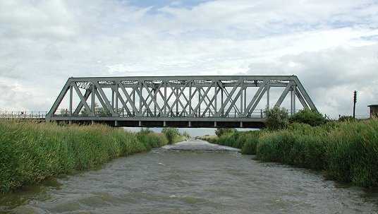
The line is double track, non-electricfied. There are bridges across three rivers: Counter Drain, The Delph and The New Bedford; and a road bridge over the Hundred Foot Bank. In the Washes, the line between the Delph and New Bedford has a viaduct at each end and a central embankment.
Some signs of the original works remain. See the slideshow, link from menu bar
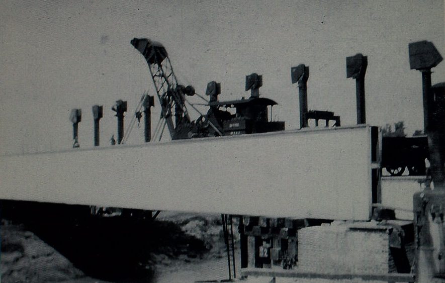
construction works in 1920s
photos from Pymoor Archives
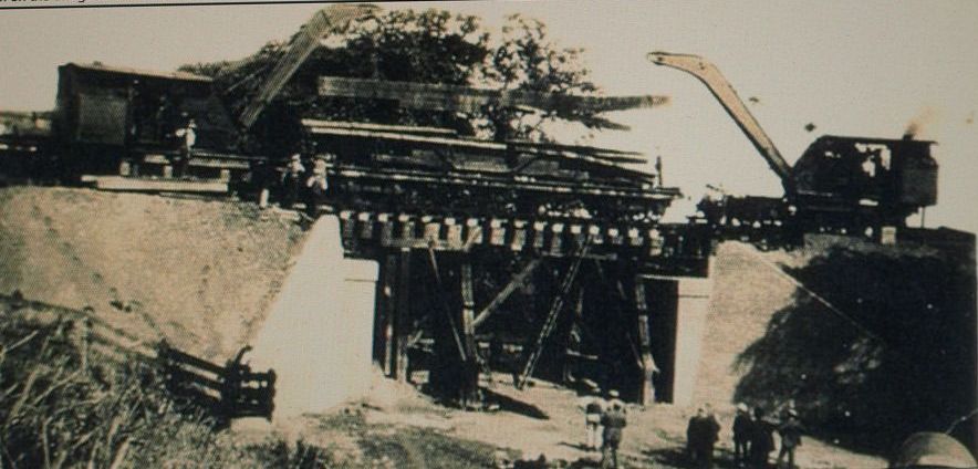
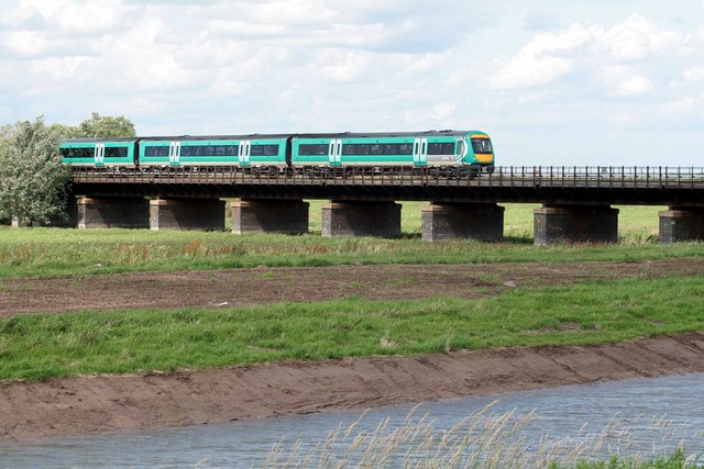
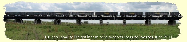
above viaduct over washes, below steel through-truss bridge over the New Bedford River
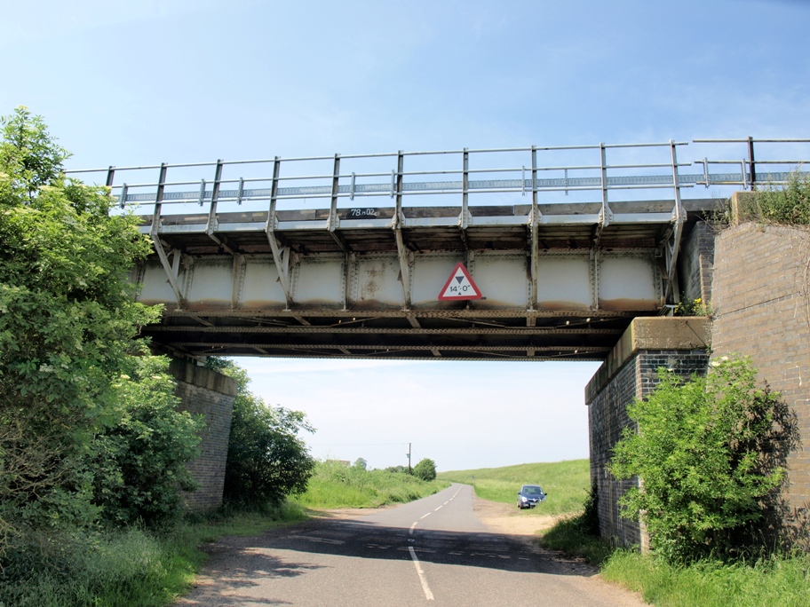
bridge over the B 1411 Hundred Foot Bank road design similar to viaduct sections
many more photos on railway slideshow
Salter's Lode
Sutton Fen, Jolly Bankers
Sutton Gault
New Bedford River

Photo: Peter Cox, Apr 2011

Photo: Peter Cox, Apr 2011
Causeway and raised footpath across Washes


water level gauge reads up to 4.2m
Photo: Peter Cox, Apr 2011
Old Bedford River

Photo: Peter Cox, Apr 2011

Photo: Peter Cox, Apr 2011
Welches Dam
Welmore Lake
Welney
Gardner's 1851 History of Cambridgeshire & Isle of Ely, page 566: "bridge over Old Bedford is cast iron, the Delph bridge is timber"
The earlier cast iron bridge, below,

was recorded in Gardner's 1851 History
of Cambridgeshire and Isle of Ely

The foundations of the cast iron bridge are clearly visible under the current bridge (see also right column)

or are there two lots of previous foundations, one wider than the other?

Old Bedford River

Photos of Cast Iron bridge courtesy of The Welney Website; all others: Peter Cox, May 2011


Delph River

Photos: Peter Cox, May 2011

A water level gauge reads up to 6m a metre higher than any others I've found in the Washes.
The plastic pipe looks like it might contain part of a sophisicated electronic system for measuring water level or flow, with readings sent to the EA control centre via telemetry.
For more information seeTelemetry
The underside was much as expected.

except for one or two things:

birds nest

lager bottle carefully disposed of

some corrosion

box of tricks part of telemetry system? click to see the full system.
Photos: Peter Cox, Jun 2011
New Bedford (Hundred Foot) River at Suspension Bridge

Aerial photo: courtesy of Dick Fiske, Jun 2005

Looking southwest from east bank
Photo: Peter Cox, Jun 2011

Looking north from east bank
Photo: Peter Cox, Jun 2011
Acknowledgements
Text and photos except where noted © Peter Cox, 2010-26If you think there are any errors or ommissions on this page or would like to comment, please e-mail me and your response will be added.