- Main pages of this site
- Contents of this page
Introduction
This page suffered from loss of images when the web-host transferred servers in Dec 2020. Some have now (Oct 2021) been re-posted, but in doing so I realised the whole page needs revision which will be dealt with laterWithin the parish of Welney there is a hamlet of some 15-20 dwellings known as Suspension Bridge situated on the eastern side of the New Bedford/the Hundred Foot River at a point where the A1101 Littleport to Wisbech road crosses the river.
 .
.|
page last updated 07 October 2021 |
| If visted before, please "refresh" page to see latest version. |
1652-1826
The river here is tidal, and man-made. It was cut in the 1650s as part of Vermuyden's grand plan to drain the land and some references say a wooden bridge was errected at that time. The river and adjacent land was owned by the Bedford Level Corporation (the successors to the original "Company of Adventurers" who employed Vermuyden) and was probably responsible for maintaining that bridge. However, the Corporation was always short of cash and it is likely that the bridge crumbled away due to neglect. We may never know the true details as many of the Corporation's early records were destroyed in a fire.No bridge is marked on the OS 1" map of 1824 (which shows the area as 'Washington') and a ferry service had been in use here for many years before that.
back to contents
1826, The Suspension Bridge
Then in September 1825 the Revd. William Gale Townley, the rector of the parish of Upwell (of which Welney was then a part) leased a strip of land from the Corporation for 99 years in order to build a bridge. The Rev. Townley financed the cost, around £3,000, but was allowed to charge tolls at rates set out in the lease. The bridge was designed by Captain Sir Samuel Brown, RN, a naval officer and engineer, and was of a relatively new style, a chain suspension bridge, completed in 1826. It was of wrought iron with a timber deck. It was 191 feet (58.5 metres) long; the carriageway was 7ft 6ins wide, with a 3ft 4 ins footpath each side. It was opened to the public on 16th August 1826 and was described as a "handsome" bridge.
Above, looking north. The toll house was on the east bank (the building with tall chimney). Just across the road was the Crown Inn (the white building) and there are tales of the toll collectors spending much of their time in the pub, having paid a young boy to keep watch outside. The photo on the left shows a charges board on the left tower, and the toll house to the left of it. The last toll keepers are said to have been Roger Lavender and Larry Scott.
The bridge was designed when horse drawn waggons were the heaviest traffic. Steam traction engines introduced towards the end of the Victorian era and later steam and petrol lorries damaged the bridge and by the 1920's a three-ton weight limit had been imposed. Barber's Almanack records that Littleport Parish Council in May 1925 discussed its "dangerous state".
back to contents
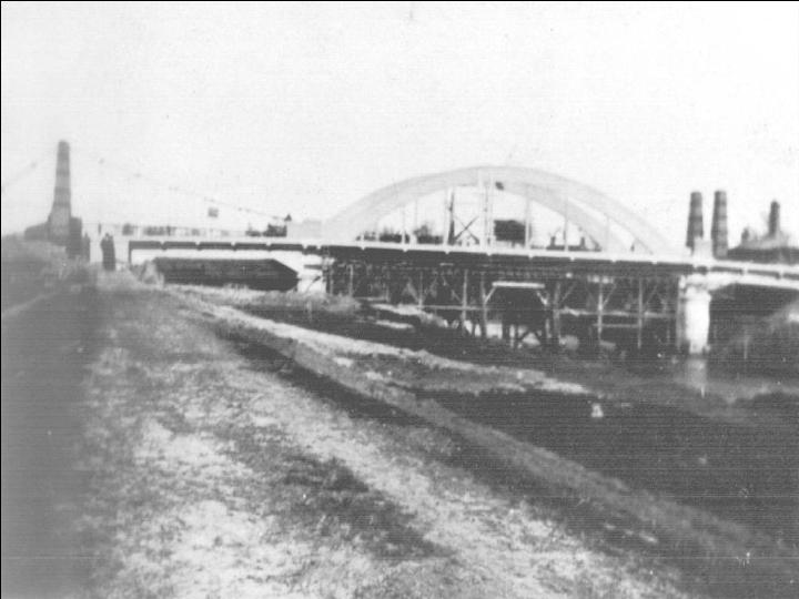
1926, concrete bow-string bridge
So, in 1926, it was replaced by a three-span bridge of reinforced concrete with a central bowstring arch and two short approach spans.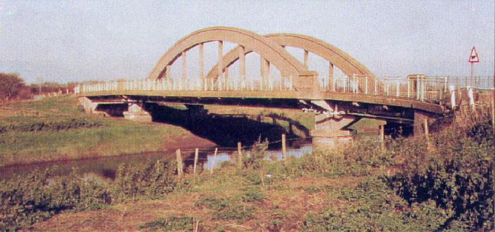 The new bridge was erected south of the original bridge as shown below.
Note the toll house is still there. It may have been co-incidence that the new bridge
was built so soon after the expiry of the Rev. Townley's lease, but I suspect not. The
Bedford Level Corporation ceased to exist in 1920, which may also have been a
contributory factor. I also assume the new bridge was financed by the County Council.
The new bridge was erected south of the original bridge as shown below.
Note the toll house is still there. It may have been co-incidence that the new bridge
was built so soon after the expiry of the Rev. Townley's lease, but I suspect not. The
Bedford Level Corporation ceased to exist in 1920, which may also have been a
contributory factor. I also assume the new bridge was financed by the County Council.back to contents
1994
This bridge too suffered from traffic far heavier than was invisaged when built. In the 1920s the largest normal lorries would probably have had a gross weight of about 10 tons, and there weren't many around. Increases in lorry weights and traffic volume caused structural problems and when Norfolk County Council engineers examined the bridge in the early 1990s they assessed it to have a weight limit of only 7.5 tonnes - but it was being used daily by trucks of up to 38 tonnes! Later a more detailed investigation was undertaken by the chartered engineers, Maunsell & Partners who concluded that it could not be strengthened sufficiently to meet the required EU standard. The County Council therefore sought Government funding for a new bridge and in 1992 commissioned Maunsell to carry out feasibility studies. Various designs and alignments were considered.The final selection was a three-span bridge with reinforced concrete piled foundations, steel main beams and a reinforced concrete deck, with an overall length of 50.83 metres and 11.2 m overall width, to be built just to the south of the 1926 bridge. The tender for the construction was won by May Gurney Construction Ltd. and work started in November 1995. It was completed on schedule and the new "Suspension Bridge" was opened on 23 September 1996 by Mr R Phelan, CEng MIEE, Chairman of Norfolk County Council. The scheme cost £1.4M, grant aided by the Department of Transport.
 back to contents
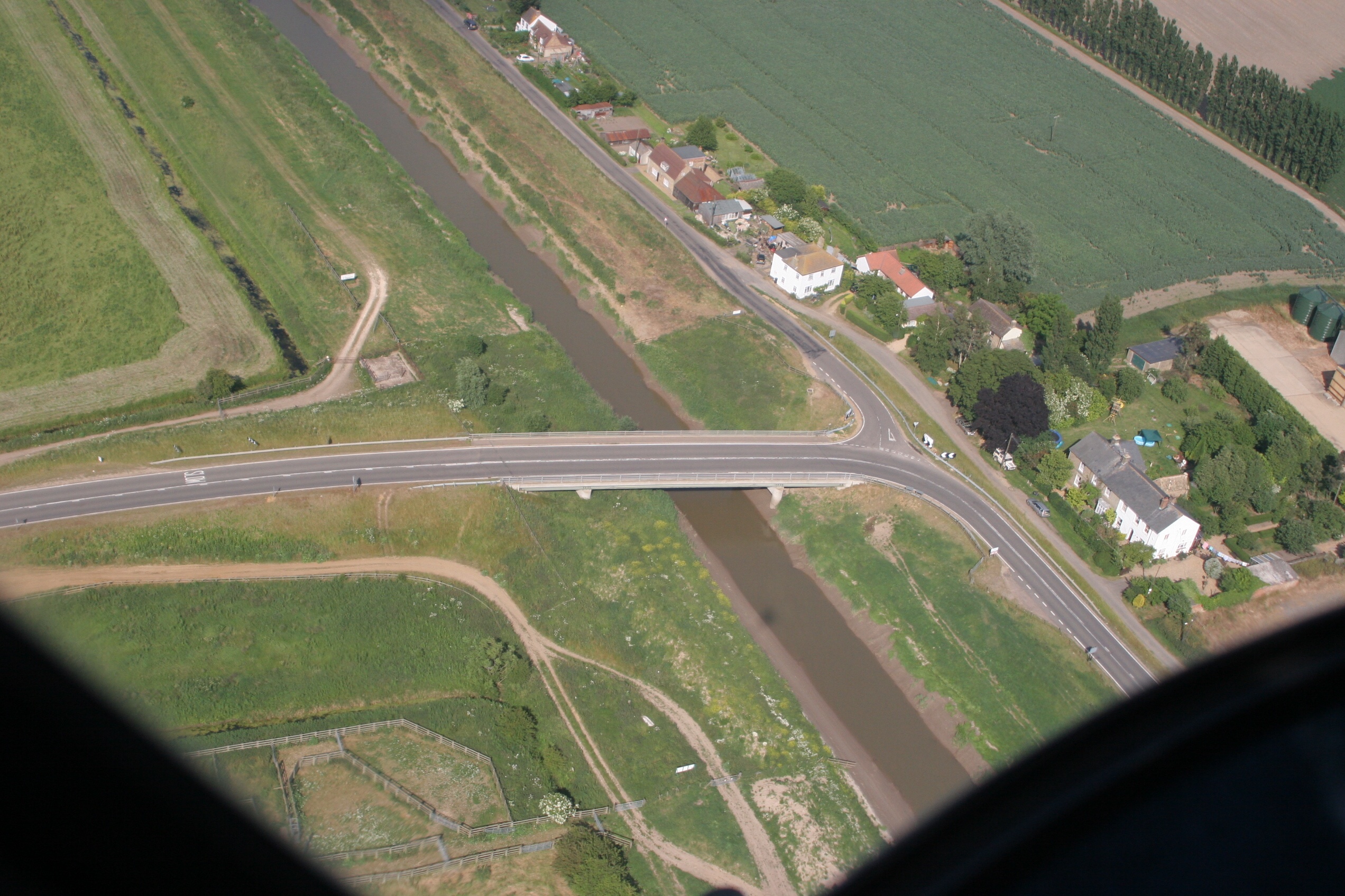
The fact that the bridges of 1926 and 1996 were built to the south of the ones they replaced means that the eastern end of the
original suspension bridge might have been in line with what is now the garden to the north of Crown House
(the large white building). The aerial views seem to confirm that.<br />
<br />
The current bridge is at a slight angle across the river to lessen the bend
on the east bank, but many parishioners commented during the planning stages
that the designed re-alignment was insufficient and that the opportunity
should be taken to eliminate as much of the bend on the main road as
possible. The planners said they were unable to do that, and accidents
have occured here regularly ever since.
back to contents
Pubs
There used to be at least three pubs here: The Crown Inn (now Crown House, left) originally owned by the Bedford Level Corporation, which closed in 1968; The Carpenters Arms (now Carpenters) closed c1940; and The Cock (probably now Kendrick Cottage).back to contents
Schools
To the north of the bridge there was a Church of England free school known as the "Mission School" (now Tall Pines) built in 1874 by Marshall's Charity for 80 pupils. It was also licenced for "divine service", held on Sundays. It closed in 1927.
The building was badly damaged by fire in April 2006.
back to contents
Chapels
To the south of the bridge there was a Primitive Methodist Chapel (now The Old Chapel, right) built in 1872.back to contents
back to contents

back to contents
- related pages on this site
- related external websites/pages
Index and links
back to contents
|
Acknowledgements. Text and photos except where noted © Eddy Edwards, 2010-12 If you think there are any errors or ommissions on this page or would like to comment, please e-mail me and your response will be noted where appropriate. |