Page good for smart-phones. On PCs/Laptops it may look too large. To reduce press "Ctrl" & "minus" or click "View" then "Zoom out"
Created May 2011, last edited:
01/04/26, 23:04
1604-2012
years
mnth
item
detail
refs
years
mnth
item
details
refs
1604
Hunt
proposed a new cut from Erith (Earith) to Salters Lode.
1630
Jan
Lyn Law
Francis Russell, 4th Earl of Bedford, contracted to
drain the Great Level, later known as the Bedford Level(s), within 6 yrs
1631
Feb
Indenture of 14 parts
Incorporation of the Company of Adventurers to fund
the works
c1632 to c1637
Seventy Foot or (Old) Bedford River dug
from Erith (Earith) to Salters Lode, to be the new route for
the Great Ouse
c1630
(Old) Bedford Sluice built at Salters Lode
at end of (Old) Bedford river to prevent tidal inflow
into the new cut from the Great Ouse
c1630
Salters Lode Lock built
where Well Creek joins the Great Ouse
1637
Oct
a Session of Sewers held at St Ives
adjudged lands drained in line with the Lynn Law;
awarded 95,000 acres to the Adventurers
1638
Apr
a Session of Sewers held at Huntingdon
reversed, Oct 1637 decision; draining judged
defective
1638
Vermuyden's "Discourse"
A plan to improve drainage prepared for King Charles 1.
Vermuyden opposed embanking all rivers, instead cutting more rivers
and creating washlands as temporary storage.
1642
Vermuyden's "Discourse"
published, with map
1642-1651
Civil War
1645
Oliver Cromwell
appointed as Governor of the Isle of Ely. Formed a
drainage committee.
1649
Act of (The "Pretended Act")
William Russell, 5th Earl of Bedford, authorised to
drain land to make fit for permanent agricultural use.
1649
Vermuyden re-engaged
to do the "second stage"
1650
Jonas Moore
appointed surveyor to the Adventurers; compiled map
of the reclaimed land showing the "lotts", ie the land allotted to
each of the Adventurers, and how the original allottments were spilt
and sub-divided many times, accounting for many (but by no means
all) the Wash fields.
c1651-c1652
Hundred Foot Drain or New Bedford River cut
from Earith to adjacent to what became Denver Sluice
navigation only possible when river levels were the
same both sides of sluice.
1649-1651
Forty Foot River cut
from Ramsey to what became known as Welches Dam
1651
Forty Foot Lock built
from 40 ft to OBR
1651
Welches Dam built
across OBR sth of Forty Foot, to turn water from 40
Ft to Salters Lode
c1652
"second phase" completed creating the Hundred Foot
Washes (later known as the Ouse Washes)
1657
William Dugdale
Commissioned by the Adventurers to write a history of
fen drainage. Didn't live in or know about the Fens. Toured the area
for 2 weeks, and consulted previous books, then wrote "History of
Imbanking and Drayning" with a version of Jonas Moore's map.
1658
Great Dyke at Mepal
"Probable" year first cut
20
1661
William Marshall
established a charity for Welney
1663
General Draining Act
established Bedford Level Corporation
1666
Great Fire of London
destroyed the Fen Office and most records of the Adventurers
& the earliest ones of BLC
to protect South Level from flooding from rivers
Lark, Wissey, and Little Ouse. Cut Off Channel from Barton Mills to
Denver and (Flood) Relief Channel from Denver to Kings Lynn.
1960-1961
(Flood) Relief Channel
Cut from Denver to Kings Lynn
1967
Model of Wash GORA workshop/lab
demolished by GORA, 1967 Coldhams Rd premises closed
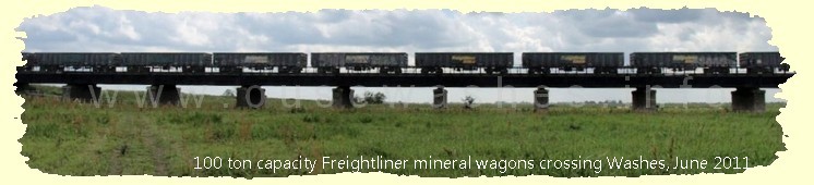
Chronology of 100 Foot/Ouse Washes
Created May 2011, last edited: 01/04/26, 23:04
1604-2012
c1637
held at St Ives
held at Huntingdon
(The "Pretended Act")
GORA workshop/lab
Coldhams Rd premises closed
(at expense of Upwell IDB)
18
Dam (proposed) in NBR nr Earith Br
Flow of Great Ouse reversed,
also Ely Ouse & Old West ?
10
10
10
If you think there are any errors or ommissions on this page or would like to comment, please e-mail Peter and your response will be added.