Page good for smart-phones. On PCs/Laptops it may look too large. To reduce press "Ctrl" & "minus" or click "View" then "Zoom out"
Created Sep 2025, last edited:
03/04/26, 16:04
Introduction
March 2026 Page Upgrade
Under reconstruction following code upgrades and changes to responsive phone-friendly display.
Some images or text may be out of order or missing but will be corrected soon.
This river forms the eastern side of the Washes. It is classified as a "main river" and therefore managed by the Environment Agency. It is tidal, and is a stretch of the River Great Ouse (RGO).
The common abbreviations are HFR, NBR, HFR/NBR or NBR/HFR.
It starts from the Bedford Ouse (BO) 0.5km east of Earith Sluice, and runs to Salters Lode where it becomes commonly known as the Tidal River (TR) another stretch of the RGO.
Under 'normal' (non-flood) conditions, water from the BO (yet another stretch of RGO!) flows down the HFR and is discharged to the sea via the TR/RGO. Levels in the HFR are affected by BO fluvial flow and King's Lynn tidal levels. There are no control structures on the BO, HFR or TR/RGO between Brownshill Staunch and Lock and the sea at King's Lynn.
Water levels are also affected by the operation of Earith sluice, Denver
sluice and discharge of local drainage water from three Internal Drainage Board (IDB) pumping stations. Most IDBs also take water from the river in summer by gravity through "slackers" (small
vertical wind-up sluice gates.) Plan: Environment Agency
History
The river was cut (constructed) in 1652 under Vermoyden's plan to make a flood-water reservoir, the other side being the 1637 OBR/DR.
Scroll down to follow the story or choose a section to jump to from the drop-down menu.
A slacker is a small sluice gate to allow one-way passage of water.
There are 17 slackers allowing water onto the Washes for irrigation, and 5 into the South Level This section is based largely on the EA's Ouse Washes Water Level Management Plan produced by the Halcrow Group in 2002.
"The Hundred Foot River is the only available source of water for maintaining water levels in the internal ditches. The river is tidal and water can be
drawn only during high tides, a period of between six and seven days each fortnight.
The total amount of water available depends on a combination
of the tide height, fluvial flow and weather conditions. During dry summers there may be insufficient water available to top up ditches to the optimum
level, and compromises have to be made.
Water enters the internal ditches through the seventeen inlet slackers in the Cradge Bank, the west bank of the NBR, the locations of which are shown on Figure 5. The slackers are of varying designs and dimensions, and are situated at different levels. The Hundred Foot IDB has an ongoing programme to replace or repair faulty slacker control equipment.
Water comes through the slackers into a header dyke, which runs parallel to the Cradge Bank. The aim is to bring water into the system as steadily as
possible. If the slackers are opened too wide, particularly on a high tide, water enters the system too fast. Fast-flowing water carries a large silt load,
erodes dams and fills ditches too quickly, causing localised nuisance flooding.
However, on a neap tide it may be necessary to open the slackers fully to
bring in sufficient water over a short period. Under such conditions water levels in the header dyke will be temporarily raised, and internal water control
structures must also be raised to prevent flooding. Normal IDB practice is to install gaugeboards to monitor the water levels. (continued after plan and data table) Plan: Environment Agency
With phone in landscape view, the slacker numbers on this plan can be easily read, and then refer to IDB ref on table below for slacker details.
Source: NRA OW WLMP, March 1996; EA OW WLMP, 2002,
Fig 6 for HFW IDB refs.
(text continuned from before plan)
Once water has entered the system it is necessary to distribute it in the most efficient and equitable way. Water in the header ditch can flow in either direction.
Each slacker feeds a defined section of the Washes. The area of the different sections varies considerably (see Appendix 10c). In order to get water to the most
distant ditches it is necessary to use the temporary head created by tidal influx to best effect by expediting its passage through dams, culverts and water
control pipes. The controls in ditches nearest the inlet are set at the highest position early on in the cycle, to enable water to flow into the more distant
ditches. Ideally the most distant ditch should start to take water at the same time as the nearest one, although in practice the nearer ditches usually receive
water earlier.
There is a natural, albeit small (0.3 to 0.45m), gradient ac`ross the Washes from the Hundred Foot River to the Old Bedford/Delph River.
Most ditches crossing the Washes have four or five water control points along their length, including one at the junction with the Cradge Ditch and another
at the bottom of the ditch by the Old Bedford/Delph River. In years with summer floods, only the upper two or three sections of ditches have required topping
up, as high water levels in the Old Bedford/Delph River have helped to maintain ditch levels in the lower part of the system.
When river levels drop, the lowest
part of the ditches need topping up. Most ditch outfalls have control structures, which are set during the summer to ensure that no water flows into the Old
Bedford/Delph River.For the slackers and ditch systems operated by the Hundred Foot Washes IDB, annotated maps on a 1:10,000 scale have been produced
giving outline details of the current working procedures. These are not included in this document, as they are working documents subject to continual
amendment, but further information can be obtained from the Hundred Foot Washes IDB Wash Superintendent at the RSPB Ouse Washes Reserve."
From south to north
No.*
inlet from
to
OS grid ref
built/rebuilt
owner
Earith 100ft
NBR/100Ft
Haddenham Level DCA
Black Sluice
34
NBR/100Ft
Washes
Hundred Foot IDB
Youngs Holt
32
NBR/100Ft
Washes
Hundred Foot IDB
Sutton Drove
31
NBR/100Ft
Washes
Hundred Foot IDB
Sutton Gault
NBR/100Ft
Haddenham Level DCA
Reads
30
NBR/100Ft
Washes
Hundred Foot IDB
Witcham Gravel
28
NBR/100Ft
Washes
Hundred Foot IDB
Jerusalem Drove
NBR/100Ft
Littleport & Downham IDB
Pontoon Wash
27
NBR/100Ft
Washes
Hundred Foot IDB
Common Wash
26
NBR/100Ft
Washes
Hundred Foot IDB
Ely Singers
25
NBR/100Ft
Washes
Hundred Foot IDB
Oxlode
22
NBR/100Ft
Washes
Hundred Foot IDB
Oxlode Irrigation
NBR/100Ft
L&D IDB
Littleport & Downham IDB
Cambient
18
NBR/100Ft
Washes
Hundred Foot IDB
Dimmocks
17
NBR/100Ft
Washes
Hundred Foot IDB
Hundred Foot
NBR/100Ft
L&D IDB
Littleport & Downham IDB
Hartleys
13
NBR/100Ft
Washes
Hundred Foot IDB
Kents
11
NBR/100Ft
Washes
Hundred Foot IDB
Motts
7
NBR/100Ft
Washes
Hundred Foot IDB
Deptfords
4
NBR/100Ft
Washes
Hundred Foot IDB
Charity
2a
NBR/100Ft
Washes
Hundred Foot IDB
Hagen Smart
2
NBR/100Ft
Washes
Hundred Foot IDB
*.from fig 6, schematic water movement in OW WLMP by Halcrow
Hundred Foot or New Bedford River
Created Sep 2025, last edited: 03/04/26, 16:04
Introduction
Some images or text may be out of order or missing but will be corrected soon.
The common abbreviations are HFR, NBR, HFR/NBR or NBR/HFR.
It starts from the Bedford Ouse (BO) 0.5km east of Earith Sluice, and runs to Salters Lode where it becomes commonly known as the Tidal River (TR) another stretch of the RGO.
Under 'normal' (non-flood) conditions, water from the BO (yet another stretch of RGO!) flows down the HFR and is discharged to the sea via the TR/RGO. Levels in the HFR are affected by BO fluvial flow and King's Lynn tidal levels. There are no control structures on the BO, HFR or TR/RGO between Brownshill Staunch and Lock and the sea at King's Lynn.
Water levels are also affected by the operation of Earith sluice, Denver sluice and discharge of local drainage water from three Internal Drainage Board (IDB) pumping stations. Most IDBs also take water from the river in summer by gravity through "slackers" (small vertical wind-up sluice gates.)
History
The river was cut (constructed) in 1652 under Vermoyden's plan to make a flood-water reservoir, the other side being the 1637 OBR/DR.Scroll down to follow the story or choose a section to jump to from the drop-down menu.
Sluices and locks
Pumping Stations
Irrigation inlet slackers
A slacker is a small sluice gate to allow one-way passage of water.There are 17 slackers allowing water onto the Washes for irrigation, and 5 into the South Level
This section is based largely on the EA's Ouse Washes Water Level Management Plan produced by the Halcrow Group in 2002.
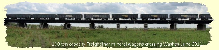
Bridges
rebuilt
Pubs & Inns
Data Sources
Notes and sources
If you think there are any errors or ommissions on this page or would like to comment, please e-mail me and your response will be added.